-Метки

"едро" "правое дело" krievija nasa polska абхазский регион агрессия россии в грузию антисемитизм апсуйские террористы бредо руссо великобритания видео выборы гаага геноцид гозман грузия еврабия звезды звери злокачественные новообразования идиоты израиль империя зла имперская ложь имперские игры иран исконно-посконное искусство ислам исламский терроризм исламский фашизм исламский экстремизм календарь катастрофы коммунизм коммунофашизм космос краснокоричневые кризис криминал криминальный ислам криминальный сепаратизм культ личности обамы культ личности путина леваки либеразм лужков маразм медведев море москва наса нато нацизм национал-социализм обсе оккупация грузии россией осетинские террористы осуждение россии палестинский терроризм польша правы только правые преступления коммунизма природа провокаторы психология птицы путен путин радикальная оппозиция российская армия российское лицемерие россия рпц русский фашизм самачабло совок сталин стихии сша терроризм тесты толерастия ублюдки уебурашка украина фальсификации фото фюреры и харизматики хамас хуссейн обама цветы цхинвальский регион черный расизм шариковы п.п. шпионаж экономика экстремизм юмор

 -Поиск по дневнику

Поиск сообщений в Cudzoziemka

 -Подписка по e-mail


 -Статистика

Статистика LiveInternet.ru: показано количество хитов и посетителей
Создан: 15.04.2009
Записей:
Комментариев:
Написано: 2594


Карта Манчестера по-русски.Маршрут движения советских танков заранее намечен красным

Воскресенье, 13 Сентября 2009 г. 19:33 + в цитатник
www.infox.ru/science/past/2009/08/26/SSSR_planiroval_zahv.phtmlДается российский перевод и текст английского первоисточника из "Гардиан".
Кто вздумает сделать репост, особенно не самые техничные юзеры, обратите внимание, - в советском, тьфу ты, расейском переводе изображение в формате .png. Который так просто добром не встанет в ЖЖ, это вам не .ipg какой-нибудь, и далеко не на всякий хостинг встанет.
Ну да англоязычный источник дает в обычном формате, и с него не убудет, что я его под катом немножко увеличила. А то русские надписи было плохо видно.


Британцы: СССР планировал захватить Манчестер

текст: Елена Ледяева/Infox.ru

В Великобритании будет впервые обнародована карта Манчестера, составленная советскими военными для захвата города. Названия улиц даны на русском языке, а жирной оранжевой чертой проведены маршруты следования советских танков.

В британском Манчестере в рамках картографической экспозиции будет впервые показана карта города, якобы составленная советскими военными на случай захвата города.

Как пишет The Guardian, карта была выпущена в 1974 году. Предполагалось, что ею будут пользоваться советские военные, в случае если «холодная война» перейдет в фазу вооруженного конфликта.

Советские танки в Манчестере

Названия улиц даются на карте на русском языке. Кроме этого оранжевым указаны трассы, по которым в город должны войти танки. Каким образом советские танки должны были попасть на территорию Великобритании, неясно.

Как отмечает издание, линии проведены без учета одностороннего движения и возможных автомобильных пробок. При проектировании маршрутов танков учитывались ширина дорог, характеристики дорожного покрытия. Старые петляющие дороги отметались сразу, поскольку именно там они могли быть остановлены британскими бойцами. Кроме этого составители карты помечали цели разными цветами: промышленные объекты — черным, административные здания — фиолетовым, военные — зеленым.

«Они много чего учли», — сообщил сотрудник университета Манчестера Крис Перкинс, являющийся организатором выставки. «Информацию, очевидно, они брали из дорожных атласов — некоторые из них являлись устаревшими», — сообщил он. Кроме этого, как предположил Перкинс, советские составители карты пользовались данными, полученными от разведчиков и с помощью аэрокосмических съемок.

Приоритетность Манчестера

У советских военачальников были абсолютно любые карты — «отсюда до Конго», однако Манчестер входил в ряд первоочередных задач, рассказал Перкинс. «Они всерьез думали, что когда-нибудь эта карта может понадобиться», — отметил исследователь.

«Без сомнения, генералы НАТО составляли точно такие же карты советских городов», — заметил Перкинс.

Путь в Британию

Каким образом карта оказалась в распоряжении британцев, точно неясно. Как пишет издание, это произошло после распада СССР.

Как пояснил Перкинс, в 1990−е годы после приватизации государственных типографий их новые владельцы стали в массовом порядке продавать документы, изданные в советские времена. «Они продали на Запад столько, сколько могли, недостатка в покупателях не было», — заявил он. «Я знаю, что министерство обороны (Британии) в 1991 году даже отправило целый грузовик, чтобы забрать все, что они были способны увезти», — пояснил исследователь.

Карта будет впервые продемонстрирована в рамках выставки, которая откроется в Манчестере 27 августа. www.infox.ru/science/past/2009/08/26/SSSR_planiroval_zahv.phtml

Tank tracks to Trafford: how USSR planned to invade Manchester

As Edward Heath wrestled with the oil crisis and three-day week more than 40 years ago, Soviet spies were mapping the UK

prague tanks

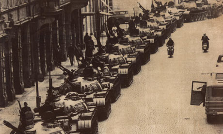
Soviet tanks lined up on a street in Prague six years before plans were printed in case of a similar incursion into Manchester Photograph: AP

1974 was a terrible year for Manchester, with United relegated to the second division for the first time in four decades and power cuts forced by the three-day week declared by Edward Heath's collapsing Tory government.
But the city would have been even more jittery had it known that in Moscow Soviet generals were eyeing the A56 between Deansgate and Stretford and checking that T-72 battle tanks could use the Mancunian Way.


A 1974 map reveals how the Soviet Union planned to invade Manchester Link to this audio
Leaving nothing to chance, maps for an armoured invasion of the city were secretly printed that year, for distribution to frontline commanders should the cold war turn hot. Ignoring one-way streets and rush hour jams, they marked the lines of an assault in bold orange, sweeping into the centre past Old Trafford and the current site of the Manchester Museum of Science and Industry.
"There wasn't much they missed," said Chris Perkins, a lecturer in geography at Manchester University, and the organiser of an exhibition opening tomorrow which reveals the map to its potential victims for the first time.
"They clearly took information from road atlases – some of them not quite up to date – but they also had details on nuclear sites and Strangeways prison, which the Ordnance Survey of the day had deliberately left out."
The chart, with its Cyrillic transliterations of place names such as Salford, Urmston and Hulme, was part of a worldwide programme drawn up with the conscientious attention to method typical of Soviet bureaucrats.
A-list
Perkins, whose display at the John Rylands library celebrates this week's Royal Geographical Society annual conference in Manchester, said: "They had maps of everywhere from here to the Congo, but this is an 'A-l ist' effort – a place which they really thought they might need to know one day."
Researched fewer than 40 years ago, the map used road widths and load-bearing statistics to plot advance routes for tanks, ruling out older, crooked lanes where armour might be trapped by urban guerrilla warfare. The Soviet planners also used a colour code for local objectives: industrial sites in black, administrative buildings purple, and military installations green.
Given the highest security during the Brezhnev years, when mutual goading was part of the UK-Soviet relationship, the map came to light after the collapse of the Communist system. Along with similar charts of other western and US strategic centres, it was sold by military mapmakers in the chaotic aftermath of perestroika and glasnost.
"The managers of individual printing factories basically went native," said Perkins, whose exhibition of 80 Manchester-related maps is on display until 17 January. "They sold as much stock as they could on the western market, where there was no shortage of customers. I know for a fact that the Ministry of Defence sent a van over there in 1991, to pick up as much as they could."
The maps were analysed to get a sense of Soviet spies' efficiency, which fell down on the intricacies of the then-developing industrial estate at Trafford Park. Like many local visitors, the mapmakers got lost in the maze of new factories, and decided to steer their tanks past on the A57 and the Chester Road.
"No doubt Nato were doing similar things in Russian cities, although perhaps not with the same incredible detail," Perkins said. "The Soviet military used everyday UK Ordnance Survey maps and publicly available road atlases and trade directories. But they supplemented it with aerial sources, such as spy planes and satellite imagery. And there's so much extra information, that it would be fair to assume that they were able to gather a considerable amount of intelligence on the ground."
Utopian plan
The map hangs alongside part of the first large-scale survey of Manchester, published in 1794. Other exhibits include a Utopian plan in 1945 to sweep the centre away and rebuild.
There is also an "isochron" chart drawn up by the city council in 1914, which tried to calculate how long commuters took to reach the centre from all points. It was published as part of a promotion for a tramway system, which finally arrived nearly 70 years later.
A map from 1889, published by the temperance campaigners of the United Kingdom Alliance, shows the whereabouts of all Manchester's licensed premises.
The exhibition also shows how such monuments to detail have been largely superseded by digital mapping and the work of Google. But Perkins said: "There is plenty of detail on the Manchester map which you still can't get online. It's a remarkable tribute to careful, patient fact-finding."
USSR Manchester map 
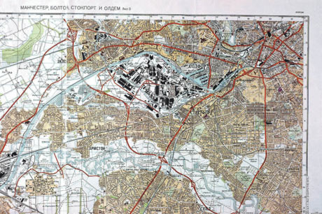
Cyrillic map of Manchester, drawn up from UK road atlases and street directories, outlining proposed access for the USSR's T-72 battle tanks - in 1974

Tense times

The cold war was still very chilly in 1974, even as the Soviet leader, Leonid Brezhnev, worked for limited détente with the west. His meetings with leaders such as the US president Gerald Ford were the public face of a policy that saw huge secret increases in military budgets.
Tension was seldom absent from international relations, particularly after the fall of Richard Nixon, Ford's predecessor, which left the Soviet Union uncertain of American intentions. The steady leeching of talent from the regime's repressive society saw Aleksandr Solzhenitsyn expelled to the US, and Mikhail Baryshnikov defect during a tour of Canada by the Bolshoi ballet.
Global recession deepened during the year and British politics was at its most troubled for decades. Two general elections ended a grim period of industrial disputes and power shortages and returned Labour's Harold Wilson to power, amid discontent and half-baked conspiracy rumours in extreme rightwing circles.

It was a miserable year for both countries in football. England failed to qualify for the World Cup and the USSR lost its place by refusing to play a match in Chile because of the recent coup led by General Pinochet.
Martin Wainwright

• This article was amended on 26 August 2009. The original referred to Irmston. This has been corrected. www.guardian.co.uk/artanddesign/2009/aug/25/ussr-planned-invasion-manchester-exhibition

27 августа 2009
Метки:  


Добавить комментарий:
Текст комментария: смайлики

Проверка орфографии: (найти ошибки)

Прикрепить картинку:

 Переводить URL в ссылку
 Подписаться на комментарии
 Подписать картинку